
The ancient Greek city of Helike (Greek: Ἑλίκη), once a thriving capital in Achaea, was destroyed by a powerful earthquake and tsunami in 373 BC. Located on the southwest shore of the Gulf of Corinth, the city sank beneath waves and sediment. Ancient writers described the disaster as a shocking event—one that wiped a town off the map overnight.
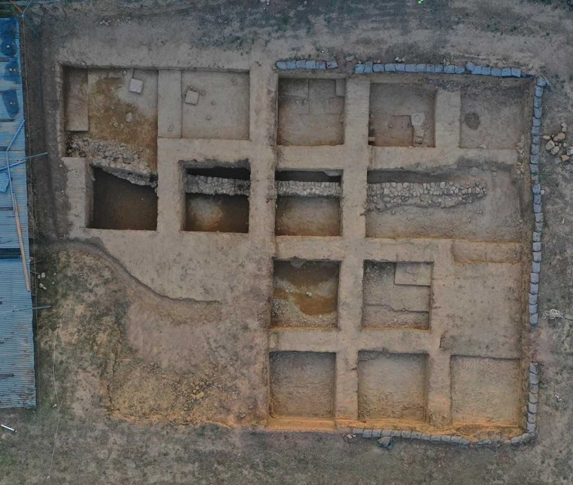
For centuries, many believed Helike lay beneath the sea. Early expeditions searched offshore but found nothing. However, in 1988, researchers shifted their focus to the coastal plain. The Helike Project used sonar, drilling, and excavation to trace the lost city’s ruins beneath layers of earth.
They found more than ruins. They uncovered a continuous record of life and destruction, dating back to the Early Bronze Age. Soil layers revealed mudflows, lagoon formations, and earthquake damage directly tied to fault activity in the area. These discoveries reshaped what researchers thought they knew about ancient seismic disasters.
A fault line reveals Helike’s violent history
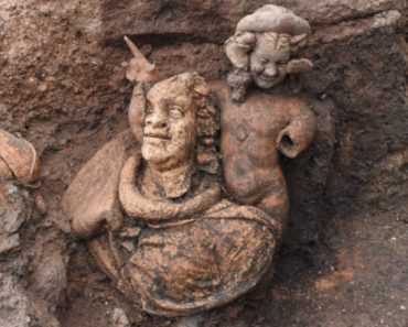
The Helike Fault runs through one of Greece’s most active earthquake zones. It stretches about 23 kilometers (14 miles) and cuts across the Helike plain with a steep, visible scar. Trenches dug along the fault exposed the aftermath of repeated earthquakes, including broken buildings and displaced graves from the Roman period.

By combining carbon dating with pottery evidence, researchers identified at least six major earthquakes over the last 10,000 years. One of the earliest, around 2100 BC, buried a Bronze Age town beneath lagoon sediments. Other powerful quakes followed in 700 BC, 373 BC, 90 BC, and the 5th century AD.
Each event reshaped the land. After the 373 BC quake, large parts of the plain flooded. But Helike wasn’t gone for good. Just decades later, a new settlement rose to the west. By the Hellenistic period, it was a center of textile production and trade once again.
Earthquakes changed the land, not the people
Despite centuries of seismic destruction, the people of Helike kept coming back. Each time the city was damaged or destroyed, residents rebuilt nearby. The region’s fertile land and coastal access made it too valuable to abandon.
Digital elevation models show just how much the landscape shifted. The quake around 2100 BC caused an uplift of 6 to 7 meters (20 to 23 feet). The 373 BC disaster dropped the land by 4 to 9 meters (13 to 30 feet), letting seawater pour inland. These changes turned fields into swamps and created lagoons where cities once stood.
Ancient texts support these findings. The Greek traveler Pausanias, writing in the 2nd century AD, said Helike’s ruins were still visible beneath shallow waters. By then, sediment had covered much of the area. Archaeologists later uncovered a Roman road running through what had once been a lagoon.
Resilience is written in stone and clay
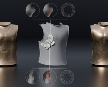
Katsonopoulou’s study shows that Helike’s people were not just mere victims; they were planners and survivors. Each disaster prompted them to change how they built. They used stronger foundations, polygonal masonry, and moved structures to more stable ground.
The research suggests a repeating pattern: disaster, relocation, recovery. After the Bronze Age town was destroyed around 2100 BC, people resettled on higher ground 1.5 kilometers (0.9 miles) away. After the 373 BC event, they built again on safer sites nearby. Even after a deadly earthquake in the 5th century AD, Roman-era residents remained in the plain.

The city’s long history of recovery points to what the researchers call a “destruction/resilience cycle.” It wasn’t just about rebuilding—it was about adapting to a dangerous environment while maintaining a connection to the land.
A modern lesson from an ancient fault
Helike’s repeated rebirths offer a rare record of how ancient societies responded to natural disasters. The study outlines a full seismic timeline for the Helike Fault, backed by both archaeological and geological data. Slip rates, recurrence intervals, and shoreline shifts were all tracked over millennia.
Researchers say the Helike case is a reminder that resilience comes from learning. Communities that understood their environment, planned wisely, and adjusted to changing conditions were more likely to survive and thrive again.
Even today, the Helike plain remains fertile and rich with history. Beneath it lie stories of survival, buried by mud, lifted by tectonics, and rediscovered by science.